Independence Excavating Is Connecting Downtown To Oakland
Independence Excavating Is Connecting Downtown To Oakland
Lifelong locals scarcely notice Pittsburgh’s landscape. Hills. Rivers. Ridges. After a couple years, it’s blasé. But these tranquil features, forged by prehistoric tectonic violence, quietly impact every aspect of how the city functions. Where you can go, what you can build, how you can move.
Their impact is particularly pronounced Downtown, whose hills are wedged inside a narrow interfluve carved out by the Allegheny and Monongahela. Possessive and occasionally temperamental, these ancient Appalachian arteries are why Pittsburgh exists at all.
They carried the barges hauling coke to the mills and their juncture births the Ohio, which brought the steel to the Mississippi, who dispersed it across a nation reforging itself with railroads, bridges, and skylines.
Though it is an ever-fading memory, steel still silently shapes this city. Its barons required riverfront factories, warehouses, rail yards, and terminals to service their mills. They also needed banks, insurers, brokers, and lawyers nearby to pay for it all.
The novel coronavirus was a global tragedy, and its timing for this city was particularly cruel. The widespread and permanent adaptation of remote/hybrid work dealt a body blow to office demand, the prime driver of downtown multifamily and retail.
Their real estate needs compounded Pittsburgh’s peculiar geographic constraints further, forcing the city’s roadways into a distorted grid so as to accommodate the large industrial parcels along the water while the inland business core evolved into a tighter street network built around foot traffic.
In that grimy heyday, people without means walked to work. The lower portion of Downtown near First Avenue was filled with small tenements, boarding houses, and rowhomes for workers. The same was true for the neighborhoods surrounding downtown. Places like the Strip, the Hill, and Uptown emerged because they could support laborers daily commute.
And since the mills were filthy and the rivers flooded, those with means wanted distance. Pittsburgh’s early elite emigrated to enclaves like Shady Side and Squirrel Hill. Institutions that serviced (or were founded by) them followed their money, setting up in a place where there was still plenty of room to build: Oakland.
For much of Pittsburgh’s history, there was never really much of a need to efficiently connect the two nodes. Steel was booming, the wealthy enjoyed their isolation, those feeding the furnaces had more immediate concerns, and the universities were respected but not yet globally influential.
That logic no longer holds. Steel is a ghost, and the universities are the economic engines propelling Pittsburgh forward. Oakland is pretty much maxed out on development, and while downtown remains the financial hub, it long ago ceased to be a dense residential hub.
As streetcars and bridges and tunnels and automobiles arrived on the scene, commuting from further out became easier. People who could leave the Downtown cauldron did. Offices gradually replaced housing until the city became overly reliant on the office sector. Its economy revolved heavily around commuters, property taxes, parking garages, and lunch crowds.
For years, this was a known but manageable concern. City leaders had been nursing downtown’s live/work/play environment back to health since the early 2000’s, and by late 2019, it felt like Pittsburgh might soon stand on its own two feet again.
By spring of 2020, it looked like the city would soon be back on life support. The novel coronavirus was a global tragedy, and its timing for this city was particularly cruel. The widespread and permanent adaptation of remote/hybrid work dealt a body blow to office demand, the prime driver of downtown multifamily and retail. It also immediately ratcheted up the economic pressure, as officials began warning of mounting fiscal issues stemming from post-pandemic property reassessments.
But as this area knows all too well, the only way out of hard times is bulldozing through them. Fortunately, since the problem had been on the radar for decades, a plan was already in the works.
In 2011, the Pittsburgh Community Reinvestment Group pointed out that to properly prosper, Pittsburgh needed much stronger transit links between Downtown and Oakland. If reliable transit between the two nodes were established, a powerful corridor would be created, allowing jobs and housing to evolve within it.
While civic leaders were well aware of what the fix was, the aforementioned existing historical and geographical constraints meant it would be easier to reroute the Allegheny than build new roads or rails. So, what to do?
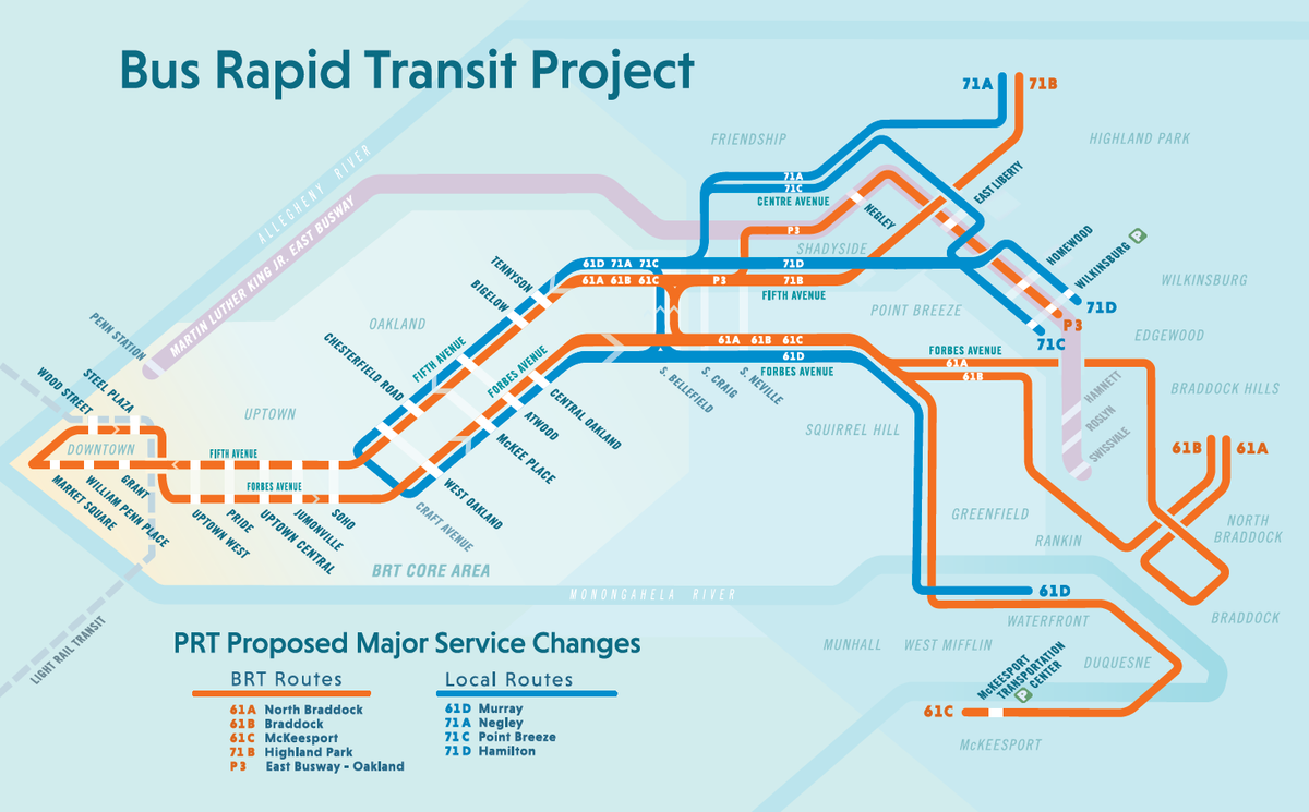
Make the existing transit infrastructure smarter and more efficient, that’s what. And in this city, there’s only one real way to do this: buses. And how do you make busses smarter? Well, this is exactly what the Pittsburgh Regional Transit’s four-phase University Loop aims to accomplish.
The full BRT plan (courtesy of Pittsburgh Regional Transit)
The University Loop is part of the Bus Rapid Transit (BRT) program and has been in the works for nearly a decade. Construction on the first stage Downtown wrapped up in 2025, and work on the second in Uptown has already begun. The final stage will be in Oakland itself, and the end result, hopefully, is a bus system between the two regions that is as smoothly dependable as rail.
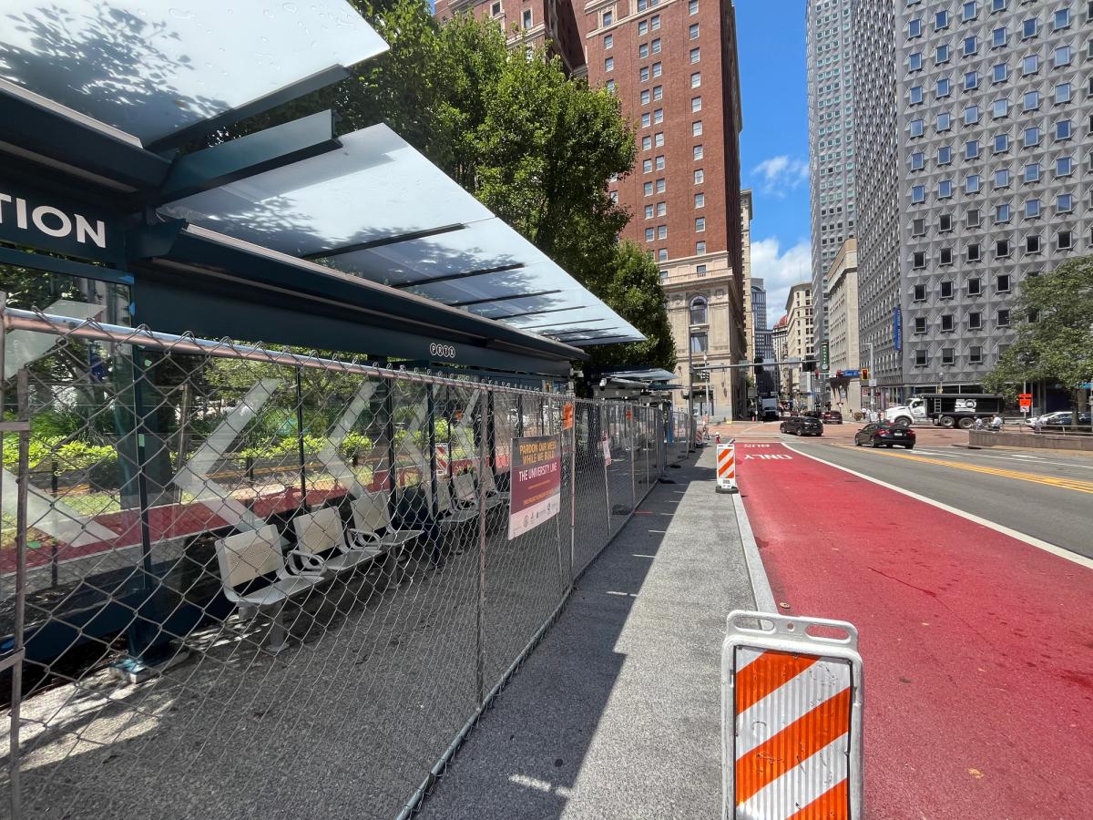
The first step toward that lofty ambition is creating consistency. That required carving out a bus-only lane into Downtown’s streets. The reason is obvious: without a dedicated space of their own it is impossible for a bus to avoid a myriad of traffic induced delays.
These delays create uneven spacing between vehicles on the same route, which is a significant problem. The technical term is bus-bunching and what happens is this: A slightly delayed bus makes more pick-ups as people accumulate at its stops. These extra pick-ups slow it down and create more drop-offs, delaying it further.
But the buses behind it pick up no one and breeze through their routes, eventually ending up a couple lights behind the first bus. That leads to uneven passenger loads and timing degradation, which makes the bus unreliable. So, people avoid it altogether and drive, which creates more traffic, compounding the cycle further.
To remedy this, the new downtown route essentially spliced a one-mile loop through the heart of the city, effectively reversing the flow of bus traffic and streamlining nine downtown routes into a single funnel.
Inbound service now enters on Fifth Avenue near the BNY Mellon building and runs west toward Market Square before turning onto Liberty Avenue and heading to the K&L Gates tower. From there, the buses quickly bounce onto Wood Street before getting onto Sixth Avenue, passing the Duquesne Club and the courthouse before exiting downtown on Forbes Avenue and heading out via Uptown.
A dedicated lane alleviates some of the issues, but it isn’t good enough for what the city needs. In order to set the standard in public transport, the buses must be intelligent. Another major component of this project was the modernization of downtown’s signal systems. Fiber optic cables were to be connected to new signals, linking intersections to an intelligent behind the scenes system that enables them to communicate and operate as a coordinated network rather than as isolated timers.
The result is a shift from static traffic control to one that can respond in real time to live street conditions. Intersections can not only detect buses, they also know how many people are on the bus. They can hold lights longer for a full vehicle and slow down other buses that are beginning to bunch. Cars, pedestrians, bicycles, and emergency vehicles are seen as they approach, and green and red lights adapt off this in real time.
This backend intelligence also enables real-time arrival displays providing up-to-the-minute service information along the downtown loop’s five sleek new shelters. Each features covered seating, enhanced lighting for visibility and safety, integrated security cameras and emergency call systems.
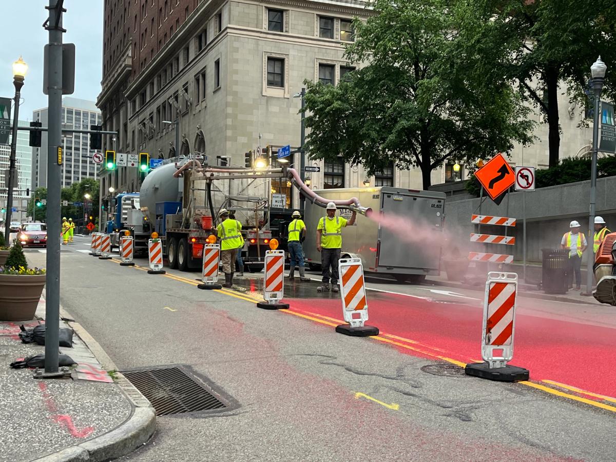
The new red bus-only lanes and shelters are the most visible part of this project, and compared to many projects profiled in these pages, not overwhelming. But the amount of work it took to achieve all of this was insane.
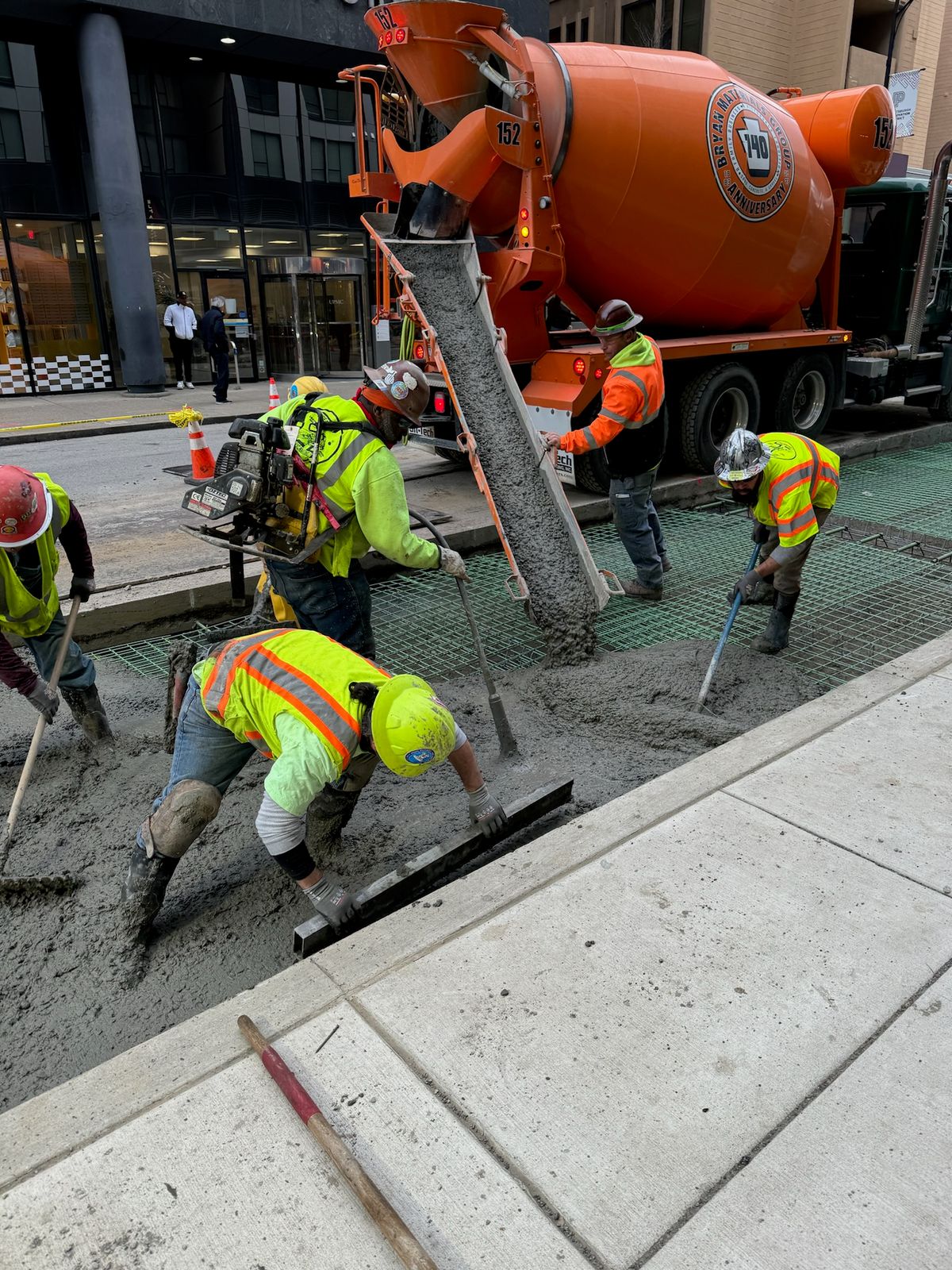
Building out the BRT wasn’t a matter of spray painting “bus only” on some downtown lanes and then plugging Claude into some lights and calling it a day. It was heavy duty infrastructure, the unglamourous work of ripping up roads and sidewalk and rerouting massive underground pipes.
“The main piece of the job,” said Matt Allanson, a project manager at Independence Excavating, the general contractor for the first phase of the BRT University Loop, “is what you can’t see.”
Independence Excavating is a Cleveland-based heavy civil contractor that has been operating since 1956, specializing in large-scale excavation, site development, demolition, environmental remediation, and infrastructure construction.
The company’s Pennsylvania branch has been involved in major operations across the region for many years, including heavy work on the Southern Beltway, the new airport, and demolishing a Neville Island coal mine. They were certainly not strangers to unique work, but ripping apart urban roads and putting them back together definitely created unique challenges.
The team’s top priority from the outset was safety.
“The streets of Pittsburgh are narrow,” said Allanson. “There’s pedestrians all over the place and traffic’s whizzing by only a foot away from the guys working.”
Maintaining safety in that type of environment required a high level of coordination and planning and attention to detail. Working crews were cramped into tight corridors with live traffic often just feet away, all the while managing heavy equipment inside narrow open trenches adjacent to critical infrastructure tie-ins.
Every movement, whether shifting a lane, setting barriers, or staging equipment, had to be carefully controlled. Traffic, pedestrians, and active bus operations all had to continue while construction moved forward, forcing the team to plan each phase of work with precision.
image courtesy of Independence Excavating
They established a disciplined communication structure early, with daily field coordination, weekly progress reviews, and consistent engagement with the owner and construction manager. Controlled work zones, clear routing, and constant monitoring allowed construction to coexist with daily city life without compromising timelines or safety.
That rhythm created real-time visibility across teams, allowing issues to be identified early and resolved before they could impact schedule or operations. Leadership also emphasized clearly defined roles, accountability, and open input from the field, creating an environment where problems were surfaced quickly and solved collaboratively.
Perhaps the most dangerous variable lurked beneath the concrete. Pittsburgh’s utility records and maps were dated, pipes weren’t always where they were expected to be, and excavation carried real risk.
“You can imagine,” said Allanson, “if an excavator bucket hit a large power line that’s running the entire city. And what that could do.”
Because the five new stations could not sit directly atop major water and electric infrastructure, and those dedicated bus lanes required far more than a fresh coat of paint, this project required constant rerouting of the massive underground piping and electrical distribution systems feeding water and power to downtown’s largest buildings.
All this done without daytime service interruption. Any mistake underground didn’t mean inconvenience; it meant life-threatening injuries and shutting down pieces of the city’s economy. Teams were trained to identify risks before work began each day, ensuring that every task, especially those involving underground infrastructure, was completed with clarity and precision.
Instead of relying on traditional excavation methods, crews adopted precision approaches like vacuum excavation and targeted utility verification, allowing them to safely expose, work around, and reroute existing infrastructure. It was controlled execution instead of brute force across multiple facets of the project.
image courtesy of Independence Excavating
The bus lanes also required reconstructing portions of Fifth, Liberty, and Sixth Avenues. Creating those lanes required substantial roadway work. Existing pavement was excavated and replaced in key sections, while crews also installed new curbs, drainage infrastructure, and utility improvements beneath the street.
Additionally, the dedicated bus lanes themselves required far more than a fresh coat of paint. Buses exert far greater weight and wear than passenger vehicles, so entire sections of the corridor needed a stronger roadway base before crews could apply the final high-friction red surface treatment that now designated the lanes.
image courtesy of Independence Excavating
The physical work brought its own challenges. Harsh winter conditions complicated concrete placement, requiring careful scheduling, heated enclosures, and specialized techniques to maintain quality and durability. At the same time, much of the most sensitive work like utility tie-ins and water shutdowns had to be performed overnight, to minimize disruption to surrounding buildings and daily operations. This around-the-clock sequencing added another layer of complexity, demanding coordination and a workforce capable of executing critical tasks under tight time constraints.
Incredibly, over the course of roughly 69,000 labor hours, the project was completed without a single incident. Work wrapped up in late 2025, and Independence Excavating was selected as the GC for phase two of the project, which is already underway.
City leaders long involved in nurturing a Downtown renaissance are excited.
“This new connectivity between Oakland and downtown will reduce travel time between the region’s two largest employment nodes from eight to thirteen minutes,” said Aaron Sukenik, vice president of District Development at the Downtown Pittsburgh Partnership.
“But the major opportunity we see is the potential transformational effect over time. We hope to accelerate this transformation of downtown from 66 percent of real estate square footage being office into a much more mixed-use and balanced live/work/play environment.”
Sukenik nails it. Though a shorter commute is always nice, the real value of the BRT University Loop is not travel time. It’s what the minutes and dependability can build.
In a 2025 report, the Brookings Institution argued that more housing Downtown could help offset some of the pandemic’s financial pressure by bringing more middle-class taxpayers back into the city. If workers and students trust that a clean and safe bus will quickly take them from Downtown to the universities and hospitals and back again, then Pittsburgh’s multifamily demand gets a boost.
New residents would support retail activity, create new streams of tax revenue, and reduce the risk associated with converting dated properties into multifamily. Oakland’s development pressure can begin spilling into the neglected in-between neighborhoods. Commercial opportunities sprout up in Uptown and the Lower Hill. Blossoming areas like the Cultural District and the Strip get even stronger.
Unlike many projects profiled in this magazine, this project’s success won’t be all that visible to the public. It’s not an inspiring church spire to be admired or a classroom that thousands will have memories of sitting in.
Few will remember the years when the city was tearing up its streets or the tough men and women who did the excavating in dangerous conditions through blistering heat and blustering cold. That won’t matter a bit.
If the University Loop helps enable Downtown to evolve beyond its historic constraints and roll into the future, then this project joins the mountains, rivers, hills and steel as part of Pittsburgh’s DNA.